Geolicious GeoCMS
The Geolicious GeoCMS is a simple contentmanagement system for creating andmaintaining interactive mapsfor yourwebsite.
The GeoCMS map gives your visitors anoverview and allows them to find routes forpedestrians, cyclists, carsand publictransport. You and your team only takecare of the content, we take care of theunique setup andhosting for you.
Look forward to personal contact with ourexperienced team and the modern, simpleuser interface that will turnyour websiteinto a modern visitor experience.
Geolicious GeoCMS in use
Over the past 8 years, we have been able touse Geolicious GeoCMS for manycustomers and support varioususe caseswith interactive map applications. Theflexibility of the GeoCMS makes it possibleto react quickly tochanges in projects.
What does the Geolicious GeoCMS web map offer your visitors?
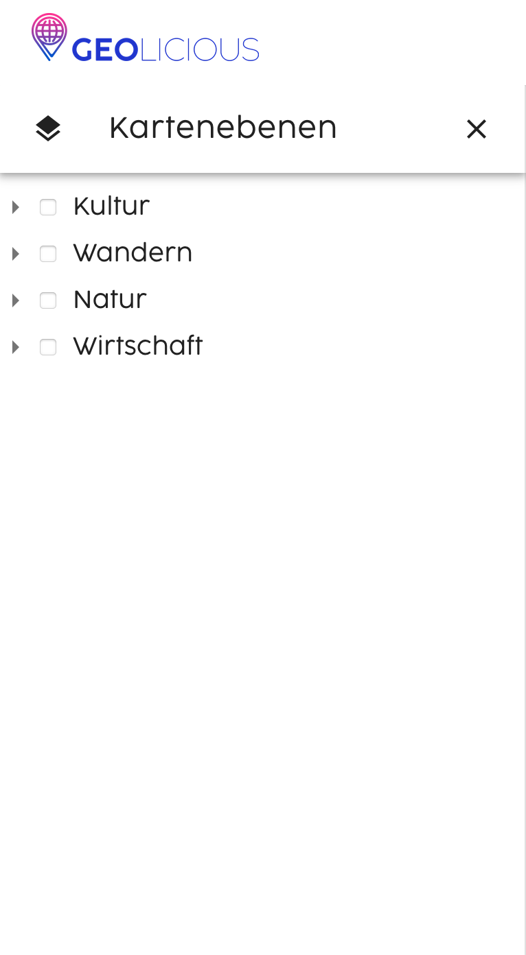
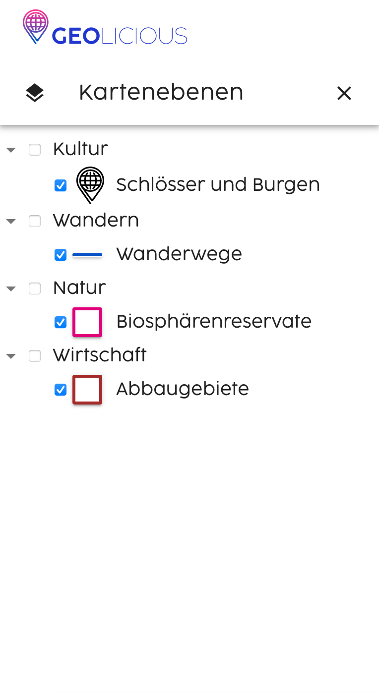
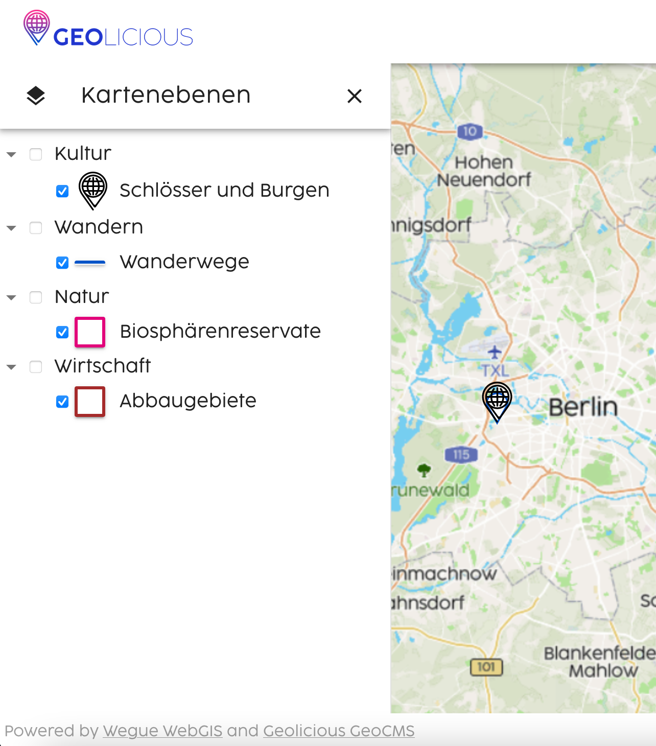
Intuitive Map Menu
In the menu “Map Layers” your visitors willfind a graphic legend with all availablecategories. Users can findand activateindividual levels grouped by keywords.
Clear information
A responsive sidebar displays informationabout objects from the GeoCMS when theyare clicked on the map. Ifavailable, thecontent is displayed in the languageselected by the user.
By using Markdown for formatting yourobject information, there are no limits tothe design of your pop-ups. You can embedvideos or other media and easily structuretexts.
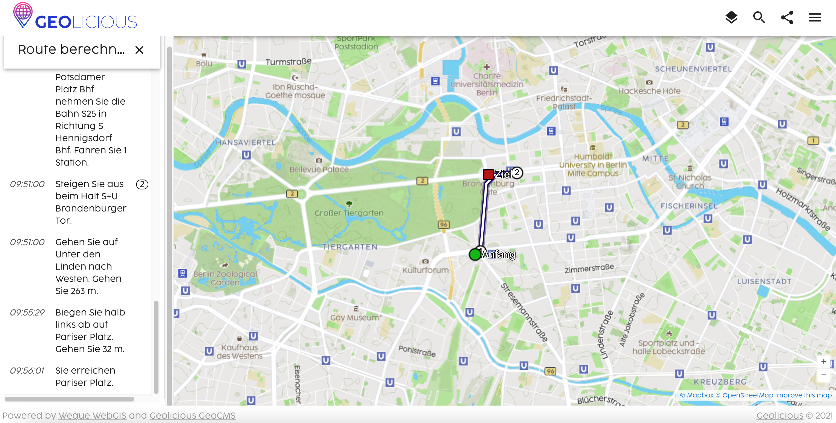
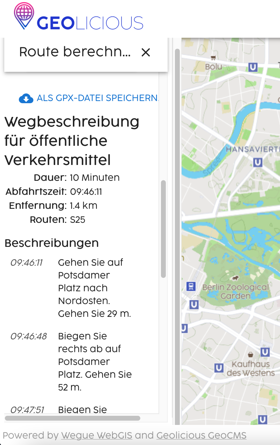
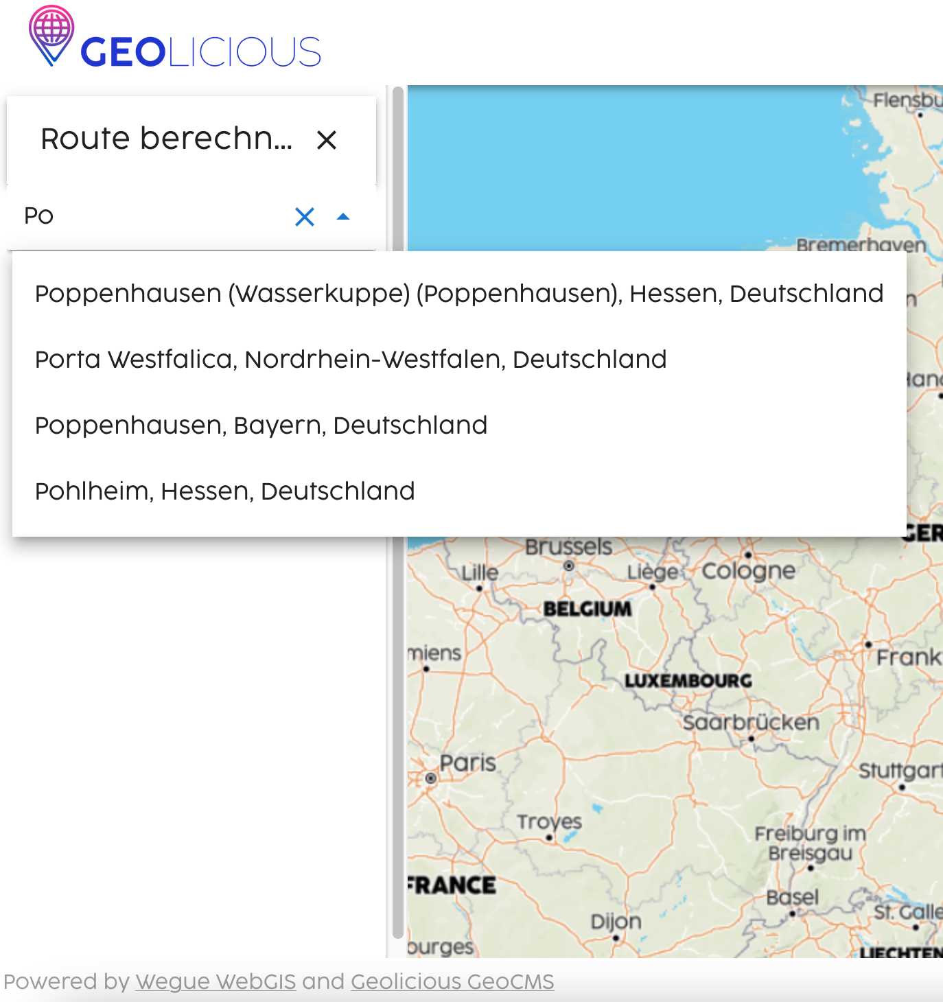
Routing – the path is the destination!
The web map offers a built-in routingfunction that provides your visitors withgraphic and textual directions.
Select start and destination via auto-completion and receive multimodaldirections for pedestrians, cyclists, carsorpublic transport.
For offline navigation, routes can also bedownloaded as a GPX file for outdoor GPSdevices or apps.
The map for on the go
Thanks to the built-in location display, therouting function and the mobile optimizeduser interface, your mapcan also be usedon the go via smartphone or tablet(internet connection required).
Users can also download the locations, routes and areas as a GPX file and use themin GPS devices ortrekking apps to find theirway around even without networkcoverage.
One search bar, two functions
Search for any address or location from theGeoCMS directly via a uniform search barand let yourself beguided there. Withauto-completion, of course. Results fromyour GeoCMS are highlighted in color.
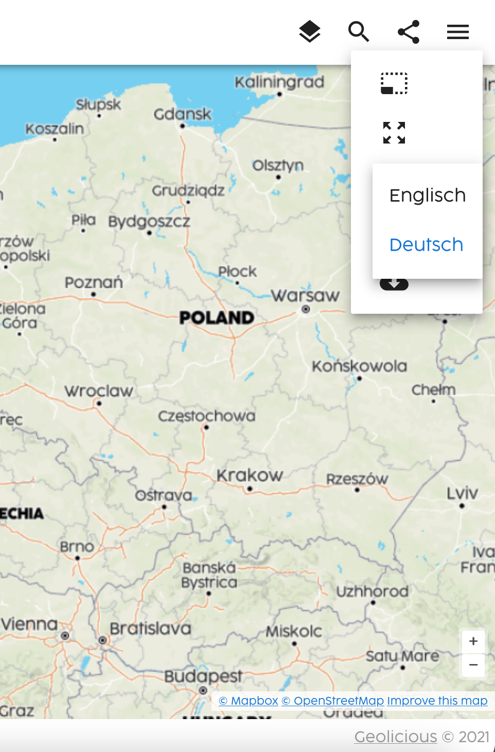
Speaks the language of your visitors
Your GeoCMS map can be translated intoany number of languages and offers theoption to display content indifferentlanguages in addition to the user interface.
In the basic version, the user interface isavailable in German and English. Additionallanguages are plannedand can be added ifnecessary. Your visitors always expect thelanguage set in the browser, or English ifthelanguage is not available.
Maps with your corporate design
Choose from different background mapsselected by us or use your own basemaps. We recommend mapsbased onOpenStreetMap. Furthermore, you canadjust all icons and color values of the mapyourself during thesetup phase, so that allelements fit seamlessly into your existingwebsite.
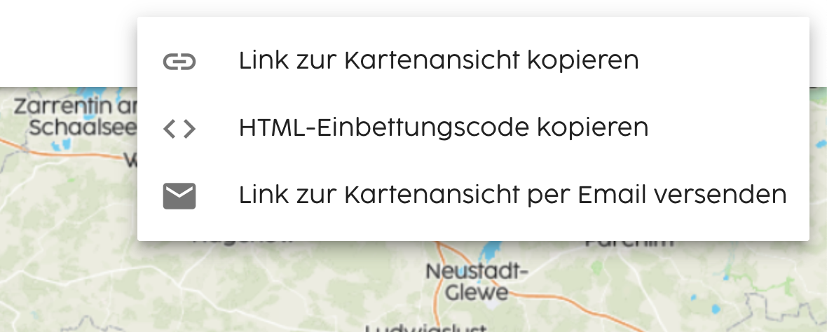
Share your map view with others
Share the current map view as URL andemail, or generate an embedded code thatallows you to embed themap on any page. This feature is particularly suitable forprofile pages of your locations.
How does data maintenance work in the Geolicious GeoCMS?
After logging into the Geolicious GeoCMS, create places, routes and areas directly inthe GeoCMS Editor. You can manage, search and filter entries inclear tables. Online Editing allows you toedit entries directly in thetable.
An import function is in planning. We arehappy to accept larger individual imports inindividual consultation withyou.
Manage categories and group them by keywords
Create your own categories and configurethe display on the map with just a fewclicks. Use your own mapmarkers andcolors.
Categories are displayed as layers on themap and can be sorted by keywords for themenu.
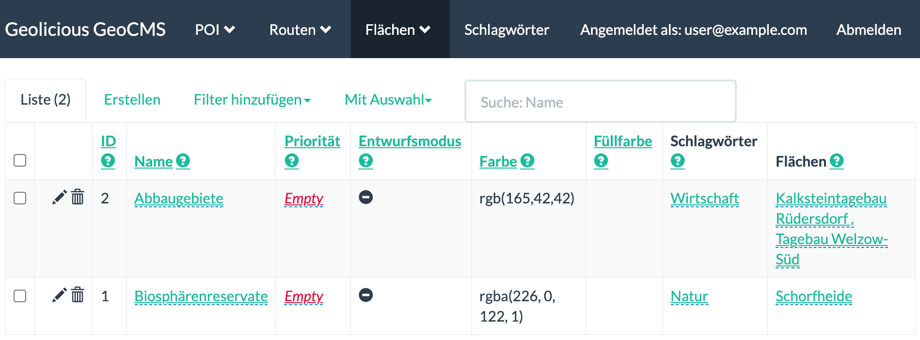
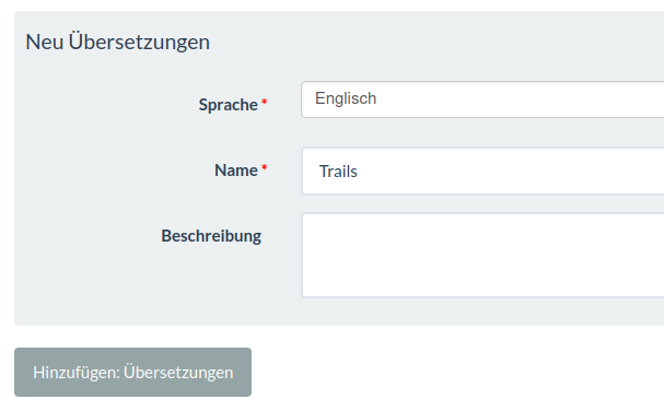
Translate content into multiple languages
Edit translations directly when creatingnew objects or simply add them later.
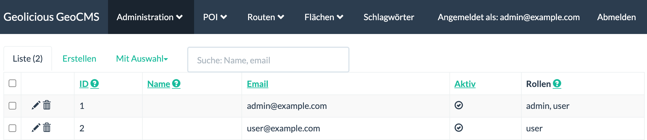
Invite multiple users for editing
As an administrator, create new accountsfor employees and partners so they cancreate and manage contentthemselves.
GeoCMS use cases
The Geolicious GeoCMS is our flexiblegeodata platform that offers a wide rangeof applications.
The location of a property significantlydetermines its demand and thus also itsprice. The Geolicious GeoCMSis the linkbetween simple object lists and theintersection with other spatial information, such as the distance tolocal services, educational institutions or surroundingrental offers and prices. In addition, we alsoadvise ourclients on the acquisition ofgeodata on real estate and their evaluation. All datasets in the Geolicious GeoCMScanbe easily edited in a team and easily usedfor display on your own website.
Leisure and tourism thrive on discoveringnew places and routes. The GeoliciousGeoCMS is used for datamanagementwhenever local offers are to be madeavailable as an interactive map for visitors. Whether skislope, nature park or even anentire holiday catalogue, interactive visitorguidance and display of additionaldigitalinformation make a successful visitorexperience these days. Manage and publishthis content easily andcost-effectively withthe Geolicious GeoCMS.
Cultural institutions and large-scale eventswith large areas or distributed locationsrequire efficient routeplanning for internaloperations, but also for visitor guidance. Our Geolicious GeoCMS supports you intheplanning and implementation of eventswith interactive information, e. g. about thecurrent stage program, the capacity of thenext museum tour and the possibility toimplement various other applications in theculturaland event environment. All contentcan be easily maintained in a team and canbe published simultaneously onexistingwebsites or in internal systems.
Various research projects addressquestions with direct or indirect spatialrelevance. Whether it is the spatialspreadof pandemics, changes in environmentalconditions or economic geography, manyof the basic data andresults can beanalyzed geostatistically and presentedinteractively on maps or in digital atlases. The GeoliciousGeoCMS offers a flexibledata structure to accommodate each topicarea, to process the data in a team andtoprocess it centrally.
The shift towards electromobility and theintroduction of intermodal transportconcepts are two key issues inthetransport transition. This is primarily aboutmore environmentally friendly and efficienttransport of goods andpeople. In order totake stock of the strategic evaluation andsimulation of new approaches, relevantgeodatamust be easily edited andpresented by interdisciplinary teams. TheGeolicious GeoCMS offers simplesurfacesand streamlined processes.
The decoupling of our energy productionfrom fossil fuels is well underway. Inaddition to the identification ofpotentialareas for the use of wind and solar energy, the transport of the generated electricity orenergy carriers(e. g. hydrogen) is alsolinked to a number of location issues andpathways. The Geolicious GeoCMS canmapany energy infrastructure (downstream) intable logics and maps, thus simplifying thestrategic planning ofprojects or the sharingof spatial information with e. g. serviceproviders. Just contact us for anindividualGeoCMS solution.
Climate change, land use and supply chainsare just three topical issues in the contextof current environmentaldebates. Sincethis is always about interactions betweenactors and regions, the spatial andtemporal evaluation(e. g. changedetection) of these issues is also playing anincreasingly important role. The GeoliciousGeoCMScan record specific data modelsand display geostatistical analyses onmaps. The creation and maintenance ofthedata takes place very easily in the team, which enables the coordination especiallyfor distributed teams. The results can thenbe easily published as interactive web mapsand thus incorporated into the currentdebate.
The Geolicious GeoCMS is our softwareplatform for all projects in which spatialcontent is to be created, maintained andvisualized online by individual editors orteams. Over the past eight years, we havedevelopedthe base further andsupplemented it with modern components. Today, GeoCMS is used in the privatesector(e. g. real estate, tourism, energy) aswell as in various non-profit organisations(churches, protectioncommissions) as wellas in science (studies) to publish complexspatial information easily and largely non-verbal via individual interactive web maps. If you have an idea and are not sure if theGeoCMS fits yourrequirements, we arehappy to provide you with a non-bindinginitial consultation.
Ask for your non-binding GeoCMS offer now!
Each Geolicious GeoCMS is individuallyadapted to your application. We will behappy to provide you with anindividualoffer. We look forward to hearing from you!